Read from 6,736 photo timestamps and 16 logged hikes across 27 days circling the island. Each locality label was tested against the trip's own coordinates; municipality labels collapse into the landmarks they actually contain.
The argument
27 days driving Iceland’s full Ring Road plus the West Fjords and Snæfellsnes, mid-July into early August 2020 - one of the few European destinations open to non-EU tourists that summer. 6,736 photos · 16 logged hikes · 76.3 km on foot. The trip’s defining structural choice: both major bonus loops, the West Fjords (Iceland’s most-isolated region) and the Snæfellsnes peninsula. Peak day 28 July (554 photos) in the SW West Fjords - almost certainly Látrabjarg cliff + Rauðasandur beach + Dynjandi waterfall. Second peak 14 July (515) in the interior, the Landmannalaugar Highland day (10.3 km / 408 m through the rhyolite mountains).
Trip shape
REY-O4d
S5d
SE-E3d
N5d
WF3d
SNF3d
REY-C4d
Reykjavik opencity + Reykjanes
S coast + interiorGolden Circle + Landmannalaugar
SE + E fjordsJökulsárlón + east villages
N + Mývatngeothermal + Akureyri
West Fjords ★★off-path peak
Snæfellsnespeninsula loop
Reykjavik closeMt Esja + return
Pace · photos per day
↑arrive
↑Mosfellsbær 350
↑Reykholt 350
↑515
↑Kirkjubæjarklaustur 473
↑Reykjahlíð 429
↑Þingeyri 554
The signature
Jul 28 · West Fjords - the trip's peak day
554 photos across Þingeyri, Tálknafjörður and Patreksfjörður - likely the Látrabjarg + Rauðasandur + Dynjandi triple-feature, the West Fjords' canonical day.
Photos
554
Region
SW West Fjords
Hike
3.5 km / 141 m logged
Context
Day 20 of 27 · the trip's off-path geographic peak
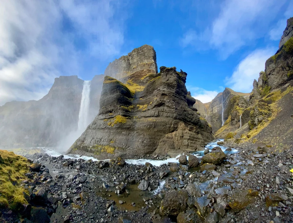
The West Fjords are Iceland’s most-isolated region - accessible only by a single road that loops through dramatic fjord-and-mountain landscape. The 554-photo day in this leg’s bottom-of-the-region villages caps a 3-day Ísafjörður-out push that the average Ring Road tourist skips.
Frame data
Duration
27 days · 26 nights
Countries
Iceland · 1 effective (DE 41 transit at Frankfurt)
Hull area
full island · ~3,000-3,500 km of driving
Anchors
moving base · 1-2 nights per stop · ~12 distinct overnight coords
Path shape
Reykjavik → Golden Circle → S coast → SE → E fjords → Mývatn → W Fjords → Snæfellsnes → Reykjavik
Photos
6,736 (6,695 IS · 41 DE)
Hikes
16 logged · 76.3 km · 2,618 m total ascent
Hike density
~41% of trip days carry a logged hike
Drive distance
~3,000-3,500 km internal
The six legs
01
Reykjavik + Golden Circle + S coast
9 → 17 Jul · 9 days
Photos
2,720
Hikes
6 logged · incl Jul 12 Reykjadalur (8.2 km / 268 m) + Jul 14 Landmannalaugar (10.3 km / 408 m) + Jul 17 Svartifoss (4.1 km / 222 m)
Shape
linear E from Reykjavik · the longest leg
Anchor
Reykjavik (3 nts open) · S coast moving
Pace
fast
Jul 14 ★ the Landmannalaugar Highland day - a long push into the interior and a 10.3 km / 408 m hike through the famous rhyolite mountains, the trip’s first true wilderness day.
Jul 9 · the long arrival, in via Frankfurt and Keflavik, a first quiet evening on the Reykjanes flats
Jul 10 · easing in with a full Reykjavik city day
Jul 11 · the Reykjanes peninsula - lava and steam at Grindavík and Hafnarfjörður, with a stop at the Bridge Between Continents and the Reykjanesviti lighthouse on the SW tip
Jul 12 · the Reykjadalur Hot Spring Thermal River walk out of Hveragerði, the trip’s first proper hike, plus a short Helgufoss walk in the Mosfellsbær valley in the afternoon
Jul 13 · Öxarárfoss at Þingvellir and the Hlauptungufoss, Midfoss and Brúarfoss Waterfalls on the Golden Circle, plus the Kerið crater and Geysir on the same loop
Jul 14 · ★ the Landmannalaugar interior day - the rhyolite mountains, the trip’s first wilderness peak
Jul 15 · Seljalandsfoss in the morning, then Skógafoss and the Sólheimajökull glacier tongue further east
Jul 16 · a deliberately quiet day around Vík and Reynisfjara
Jul 17 · ★ the big south-coast day - Reynisfjara, the Svartifoss hike at Skaftafell, and Fjallsárlón, though the Dyrhólaey arch went unvisited
02
Southeast + East fjords
18 → 20 Jul · 3 days
Photos
543
Hikes
2 logged · Jul 20 Hengifoss 4.6 km / 261 m + Rjúkandafoss 2.2 km / 62 m further north
Shape
linear N along the east coast
Anchor
Höfn (1 nt) · Egilsstaðir area
Pace
steady
Jul 18 · Höfn 230 photos - Jökulsárlón glacier lagoon and Diamond Beach, the canonical SE Iceland day.
Jul 18 · Höfn at the foot of Vatnajökull · the Jökulsárlón glacier-lagoon day, with Diamond Beach across the road and a longer dwell at the lagoon’s mouth
Jul 19 · East fjords string · Stöðvarfjörður + Reyðarfjörður + Fáskrúðsfjörður + Djúpivogur + Eskifjörður, picking up the inner fjord arm road past Lónsfjörður on the way north
Jul 20 · Vopnafjörður + Bakkafjörður + Egilsstaðir · the Hengifoss hike plus a shorter walk to Rjúkandafoss
03
North + Mývatn + Akureyri
21 → 25 Jul · 5 days
Photos
1,388
Hikes
5 logged · Jul 21 Dettifoss East Side 2.6 km · Jul 22 triple-walk (Hverfjall Volcano Crater 4.2 + Námafjall via Hverir 2.2 + Leirhnjúkur Long Trail 5.0 = 11.5 km) · Jul 23 Askja Lake 5.3 km
Shape
linear W along the N coast
Anchor
Reykjahlíð (Mývatn) 2 nts
Pace
geothermal-dense
Jul 22 ★ Mývatn day · 429 photos · 3 hikes (Hverfjall Volcano Crater · Námafjall via Hverir · Leirhnjúkur Long Trail at Krafla) - the multi-walk geothermal sweep.
Jul 21 · far NE corner · Raufarhöfn + Kópasker + Þórshöfn, with a short Dettifoss East Side walk · least-visited region
Jul 22 · ★ Mývatn cluster · Hverfjall Volcano Crater rim, the Námafjall via Hverir geothermal field, then the Leirhnjúkur Long Trail at Krafla · 11.5 km across the three
Jul 23 · continued Mývatn · a longer 5.3 km walk out to Askja Lake in the interior
Jul 24 · Akureyri · capital of the north · a quiet city day with the Kristnes and Öngulsstaðir lookouts on the east shore of Eyjafjörður
Jul 25 · N coast multi-village · Hofsós + Blönduós + Dalvík + Siglufjörður + Sauðárkrókur, with a Vatnsnes peninsula loop out to Hvítserkur on the way west
04
West Fjords ★★ - the trip's off-path peak
26 → 28 Jul · 3 days
Photos
878
Hikes
1 logged · Jul 28 Látrabjarg - Bjargtangar 3.5 km / 141 m
Shape
linear loop through the W fjord system
Anchor
Ísafjörður (1 nt) + SW W Fjords
Pace
remote / wild
Jul 28 ★★ Þingeyri + Tálknafjörður + Patreksfjörður · 554 photos - the trip’s photo-densest single day.
Jul 26 · into Ísafjörður via the Strandir east coast and the Reykhólar shore, the long approach to the West Fjords’ lonely capital
Jul 27 · the small fjord villages of Flateyri, Suðureyri and Hnífsdalur, a quiet day on a single remote road
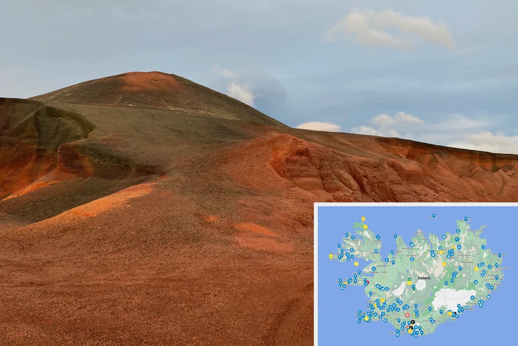
Jul 28 · ★★ the peak day of the whole trip - Látrabjarg’s bird cliffs, the red sands of Rauðasandur, and the Dynjandi waterfall, the West Fjords at their wildest
05
Snæfellsnes peninsula
29 → 31 Jul · 3 days
Photos
717
Shape
Baldur ferry across Breiðafjörður, then N → W → S around the peninsula
Jul 29 · the Baldur ferry from Brjánslækur across Breiðafjörður to Stykkishólmur, then on to Grundarfjarðarbær
Jul 30 · Grundarfjarðarbær + Ólafsvík · Kirkjufell vicinity, plus a half-day push out to Snæfellsjökull’s south foot through Arnarstapi and Hellnar
Jul 31 · Ólafsvík + Hellnar + Arnarstapi · the full Snæfellsjökull volcano loop and Búðir’s black church
06
Reykjavik close
1 → 4 Aug · 4 days
Photos
404
Hikes
2 logged · Aug 1 Eldborg 5.9 km / 96 m · Aug 2 Glymur Waterfall - East Side 7.4 km / 458 m
Shape
linear S to Reykjavik
Anchor
Reykjavik (3 nts close)
Pace
wind-down
Aug 2 Glymur Waterfall - East Side 7.4 km / 458 m - the trip’s second-longest hike, climbing to the head of Iceland’s second-highest waterfall in Hvalfjörður on the east-side approach.
Aug 1 · Borgarnes + the Eldborg crater walk in the west, then Reykholt’s hot-spring waters and Deildartunguhver on the way south
Aug 2 · Reykjavik day plus the Glymur Waterfall - East Side hike in Hvalfjörður · 458 m of ascent to the waterfall ridge
Aug 3 · Reykjavik quiet · a closing city walk before the early flight
~41% of days · 16 hikes · 76.3 km · 2,618 m ascent
Photo concentration
every region produced ≥1 day above 350 photos
Bonus loops
both - W Fjords (3 d) + Snæfellsnes (3 d) on top of Ring Road
Anchor reuse
Reykjavik twice (open + close); no other reuse
COVID open window
Iceland was one of few EU countries open to non-EU tourists July 2020
Aurora
0 nights - midnight-sun July at 64°N
Drive distance
~3,000-3,500 km internal
Off-path · per zone
Reykjavik core~5%well-photographed capital
Golden Circle~0%Iceland’s #1 day-trip
S Coast (Vík / Skógar)~0%canonical
East fjords~75%less-touristed region
Mývatn~20%well-known geothermal cluster
West Fjords ★★~90%Iceland’s most-isolated, least-visited region
Snæfellsnes~20%moderately touristed peninsula
The West Fjords + East Fjords combination drives the trip’s off-path. Both are the canonical Iceland Ring Road bonus zones - adding about six days for two minor-road detours into Iceland’s least-touristed coasts. We committed to both, making this a maximalist-Iceland trip within the driveable scope (no F-roads, no Vestmannaeyjar ferry).
absentHighland interior (F-roads, multi-day traverses)Landmannalaugar + Askja were both visited as day-loops (Jul 14, Jul 23) but no F-road-only anchor was used - no Þórsmörk, no Laugavegur multi-day traverse, no Landmannalaugar Hut overnight, no Kjölur or Sprengisandur crossing.
absentWestman Islands (Vestmannaeyjar)The famous bird-cliff ferry-island off the south coast - not visited. The May 2021 return trip targets this gap specifically.
absentHúsavík whale-watchingIceland’s whale-watching capital, ~50 km E of Akureyri - not photographed. The Norðurþing photo cluster sits at Dettifoss / Ásbyrgi, not Húsavík harbour. The autumn 2020 return brings Húsavík instead.
absentDyrhólaey archOnly a couple of photos at the Dyrhólaey lighthouse parking on Jul 17 - the famous sea arch was a near-skip while Reynisfjara beach next door drew the day’s stops. Mýrdalshreppur photos cluster at Reynisfjara, not at the arch viewpoint.
absentGlacier hiking with cramponsWalked near multiple glaciers (Sólheimajökull, Vatnajökull edge) but no on-ice hike is recorded.
absentAurora photographyJuly at 64°N is midnight-sun season - auroras are not visible. This is a sun trip, not a winter trip.
A comprehensive Iceland-by-road trip that committed to both major bonus loops (W Fjords + Snæfellsnes) without trying to add the F-road interior or the Vestmannaeyjar ferry. Maximalist within the driveable + reasonable scope. The autumn 2020 return brings Húsavík; this trip doesn’t.
Numbers
Single-day peak
554 photos · Jul 28 · West Fjords ★★
Second peak
515 · Jul 14 · interior (Landmannalaugar)
Third peak
473 · Jul 17 · Vík + Kirkjubæjarklaustur
Photos / day average
249
Walking total
76.3 km · 16 logged hikes · 2,618 m ascent
Longest hike
10.3 km / 408 m · Jul 14 Brennisteinsalda from Landmannalaugar on Laugavegur
Biggest-ascent hike
458 m · Aug 2 Glymur Waterfall - East Side
First photo (away)
2020-07-09 · Frankfurt + Keflavik arrival
Last photo (away)
2020-08-04 · Hering DE evening layover
Distance home → start
~3,500 km · flight via Frankfurt
From this trip
Where this trip surfaced elsewhere on Travelfoss. Public-facing posts and itineraries, drawn from the same days the data describes.
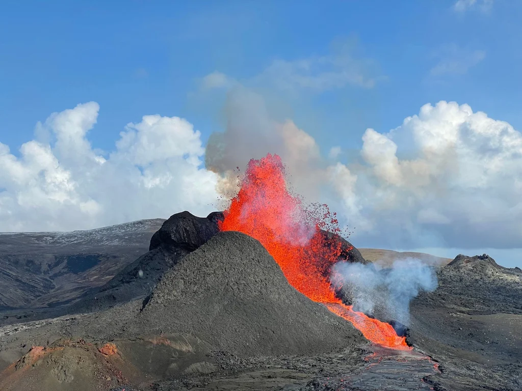
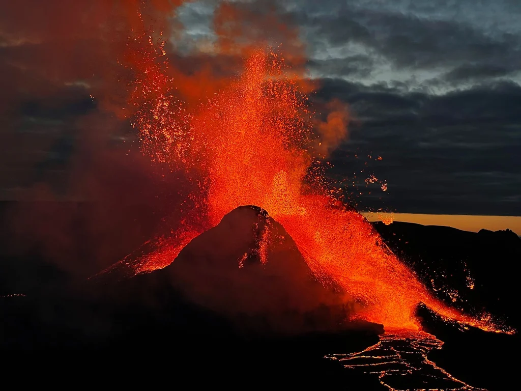
Standing next to an erupting volcano is surreal. Words, photos and videos don't make justice to being there. Feeling all the heat and the tremor and the colors is an outstanding experience. Though, …
Iceland is a country, but it feels like a different planet. It's been our second home and we know it inside out, including the top highlights for any itinerary.
Night photography has always been a challenge. Luckily, your iPhone can make very good Northern Lights shots even if you're holding one for the first time.